
搜索结果: 1-15 共查到“Three-dimensional”相关记录65条 . 查询时间(0.327 秒)
One-step self-assembly fabrication of three-dimensional copper oxide/graphene oxide aerogel composite material for supercapacitors
Graphene oxide aerogel CuO Supercapacitor Self-assembly
2023/6/21
A cylindrical composite material of three-dimensional copper oxide/graphene oxide aerogel (3DCuO/GOA) has been successfully synthesized as a supercapacitor electrode material by a convenient one-step ...
A FRAMEWORK FOR RELIABLE THREE-DIMENSIONAL UNDERGROUND UTILITY MAPPING FOR URBAN PLANNING
Underground Utility Mapping 3D Mapping Urban Planning
2018/9/12
To optimise the use of limited available land, land-scarce cities such as Singapore are increasingly looking towards the underground in search of more space. A good understanding of what already exist...
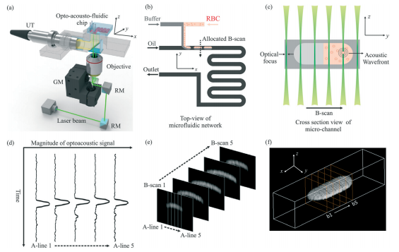
中国地质大学科学技术发展院宋潮龙等机电学院, Lab on a Chip, 27 March 2018. Opto-acousto-fluidic microscopy for three-dimensional label-free detection of droplets and cells in microchannels(图)
荧光剂;纳米颗粒;实现;物质;检测;分析
2018/5/2
2018年3月27日,微流控领域国际顶级期刊《Lab on a Chip》刊发了中国地质大学机电学院宋潮龙教授的最新研究成果:“Opto-acousto-fluidic microscopy for three-dimensional label-free detection of droplets and cells in microchannels”,该论文被推荐为封面文章。
A THREE-DIMENSIONAL AEROSOL VARIATIONAL DATA ASSIMILATION SYSTEM FOR AIRCRAFT AND SURFACE OBSERVATIONS
Data assimilation WRF/Chem Aerosol Aircraft
2018/4/30
A three-dimensional variational data assimilation system is implemented within the Weather Research and Forecasting/Chemistry model, and the control variables consist of eight species of the Model for...
THREE-DIMENSIONAL RECONSTRUCTION OF THE VIRTUAL PLANT BRANCHING STRUCTURE BASED ON TERRESTRIAL LIDAR TECHNOLOGIES AND L-SYSTEM
Terrestrial LiDAR L-system Branching structure Point cloud data Topology structure
2018/4/30
For the purpose of extracting productions of some specific branching plants effectively and realizing its 3D reconstruction, Terrestrial LiDAR data was used as extraction source of production, and a 3...
INTEGRATION OF THREE-DIMENSIONAL DIGITAL MODELS AND 3D GIS: THE DOCUMENTATION OF THE MEDIEVAL BURIALS OF AMITERNUM (L’AQUILA, ITALY)
3D GIS Documentation of Cultural Heritage Archaeological Heritage Digital Photogrammetry Archaeological Survey 3d modelling of archeological data
2018/3/30
This paper illustrates the results of an experimentation carried out by a multi-disciplinary research group made up of researchers from ITC-CNR of L'Aquila and of archaeologists of the University of L...
2018年SPIE三维和多维显微镜:图像采集和处理会议(SPIE Three-Dimensional and Multidimensional Microscopy: Image Acquisition and Processing XXV)
2018年 SPIE三维 多维显微镜 图像采集 处理 会议
2017/11/28
2018年SPIE三维和多维显微镜:图像采集和处理会议(SPIE Three-Dimensional and Multidimensional Microscopy: Image Acquisition and Processing XXV)。
2017数字全息与三维成像会议(The Digital Holography and Three-Dimensional Imaging meeting)
2017 数字全息与三维成像 会议
2017/4/25
The Digital Holography and Three-Dimensional Imaging meeting provides a forum for science, technology, and applications of digital holographic, and three-dimensional imaging and display methods. Topic...
Reflection-type holographic disk-type memory using three-dimensional speckle-shift multiplexing
holographic memory reflection-type hologram speckle shift multiplexing
2016/9/5
This review presents a reflection-type holographic memory using three-dimensional(3D) speckle-shift multiplexing. First, the schematic of the proposed memory system was described. Then, experimental d...
ESTIMATING VERTICAL LEAF AREA DENSITY PROFILES OF TREE CANOPIES USING THREE-DIMENSIONAL PORTABLE LIDAR IMAGING
Broad leaf Canopy Leaf area density Lidar Point cloud 3D Voxel
2016/2/29
In this paper, a new method for estimation of vertical leaf area density (LAD) profile of tree canopy using portable scanning lidar is
proposed. In this method, which we refer to as the voxel-based ...
Change Detection for Topographic Mapping Using Three Dimensional Data Structures
Change Detection Point Clouds Lidar Photogrammetry Topographic Mapping
2015/12/17
Identifying significant changes to our urban areas is a prerequisite for accurate topographic mapping. This paper presents an approach based on octree data structures to identify change between two se...
Red Relief Image Map: New Visualization Method for Three Dimensional Data
LIDAR Application Visualization DEM/DTM Graphics Representation
2015/12/3
The vast increase of the volume of three dimensional topographic data acquired by Airborne LIDAR extends the possibility of the visualization method. The maximum laser pulse frequency of modern LIDAR ...
NEAR REALISTIC AND THREE DIMENSIONAL VISUALIZATION OF TERRAIN USING LIDAR DATA
Immersive Visualization Geovisualization LiDAR
2015/9/28
Visualization in scientific computing has been a thrust area in the field of computer science since the last century. This has triggered
the development of technology in terms of memory, ...
a three dimensional dominant scatterer map extends the dem information in urban areas
Urban DEM InSAR Permanent Scatterer Persistent Scatterer Interferometry
2015/9/1
The generation of digital elevation models (DEMs) by space-born InSAR is a well-established remote sensing technique. Several application projects as for instance the shuttle radar topography mission ...
Determinants of international tourism: a three-dimensional panel data analysis
panel data analysis international tourism
2015/7/17
International tourism is a fast growing industry generating half a trillion dollars
in annual revenues and accounting for almost 10% of total international trade,
and almost half of total trade in s...